Hiking


Right before reaching the highest peak, 13h hike. What a ride!
Planning a roadtrip early this fall. Will be in the Ozarks for around 3-4 days. Anyone have hikes or camping spot recommendations?
I'm looking for a wiki to use and contribute to that provides information similar to what [AllTrails](https://www.alltrails.com/) provides, and functions similarly to Wikipedia. I would like for the wiki's data to be free and open, and for it to operate under a reasonably permissive license. --- Cross-posted to: https://sh.itjust.works/post/23459715

Bucamante Waterfall (Italy) - Loop trail - 5/7/24 A nice and relaxing hike during which I visited the Bucamante Waterfall (le cascate del Bucamante), in Pazzano di Sopra, Italy, then looped around Monfestino and came back to where I started [@hiking](https://lemmy.world/c/hiking) [https://www.wikiloc.com/hiking-trails/cascate-del-bucamante-e-castello-di-monfestino-da-pazzano-di-sopra-176307627](https://www.wikiloc.com/hiking-trails/cascate-del-bucamante-e-castello-di-monfestino-da-pazzano-di-sopra-176307627) The main trail starts from this church [...] [\#Wikiloc](https://mastodon.social/tags/Wikiloc) [#Hiking](https://mastodon.social/tags/Hiking) [#Trekking](https://mastodon.social/tags/Trekking) [#Nature](https://mastodon.social/tags/Nature) [#Photography](https://mastodon.social/tags/Photography) [#NaturePhotography](https://mastodon.social/tags/NaturePhotography) [#Outdoor](https://mastodon.social/tags/Outdoor) [#Italy](https://mastodon.social/tags/Italy) [#Nature](https://mastodon.social/tags/Nature)

From 2018, Manzano mountains in New Mexico, USA.
 pixelfed.social
Took me an hour to hike to this spot


Hey! Unsure if this is a thing, but are there any useful sites or apps that can predict the current snow conditions on trails? Specifically looking for info on hikes in the PNW.


Top to bottom left to right (mostly): A random shirt, running shorts, leki trekking poles, 6 moons sun umbrella, sea to summet pillow, deuce of spades poop shovel, Anker 20,000 mah battery, two cables two wall dongles, 6 moons lunar solo tent, gossamer gear Mariposa pack, titanium spoon, 54 deck playing cards, allergy pills, sunscreen, allergy nasal spray, nemo switchback sleeping pad, hoka speedgoat 5 trail running shoes, plastic bags, light buff, Patagonia puffy jacket, 2 pairs darn tough socks, 2 pairs injinji sock liners, 2 pairs aso ankle braces, skiing gloves, enlightened equipment 0°F quilt, 2 off-brand smartwater bottles, smartwool tights, outdoor research rain jacket (might replace before leaving), Patagonia fleece, jetboil stove, wool cap, Sawyer squeeze full size water filter, black diamond headlamp, running Bluetooth earphones, random tent stakes, teva sandals. Not pictured: ibuprofen, Imodium, I think I'm replacing the rain jacket with a poncho, the pixel 6 phone I took this with.

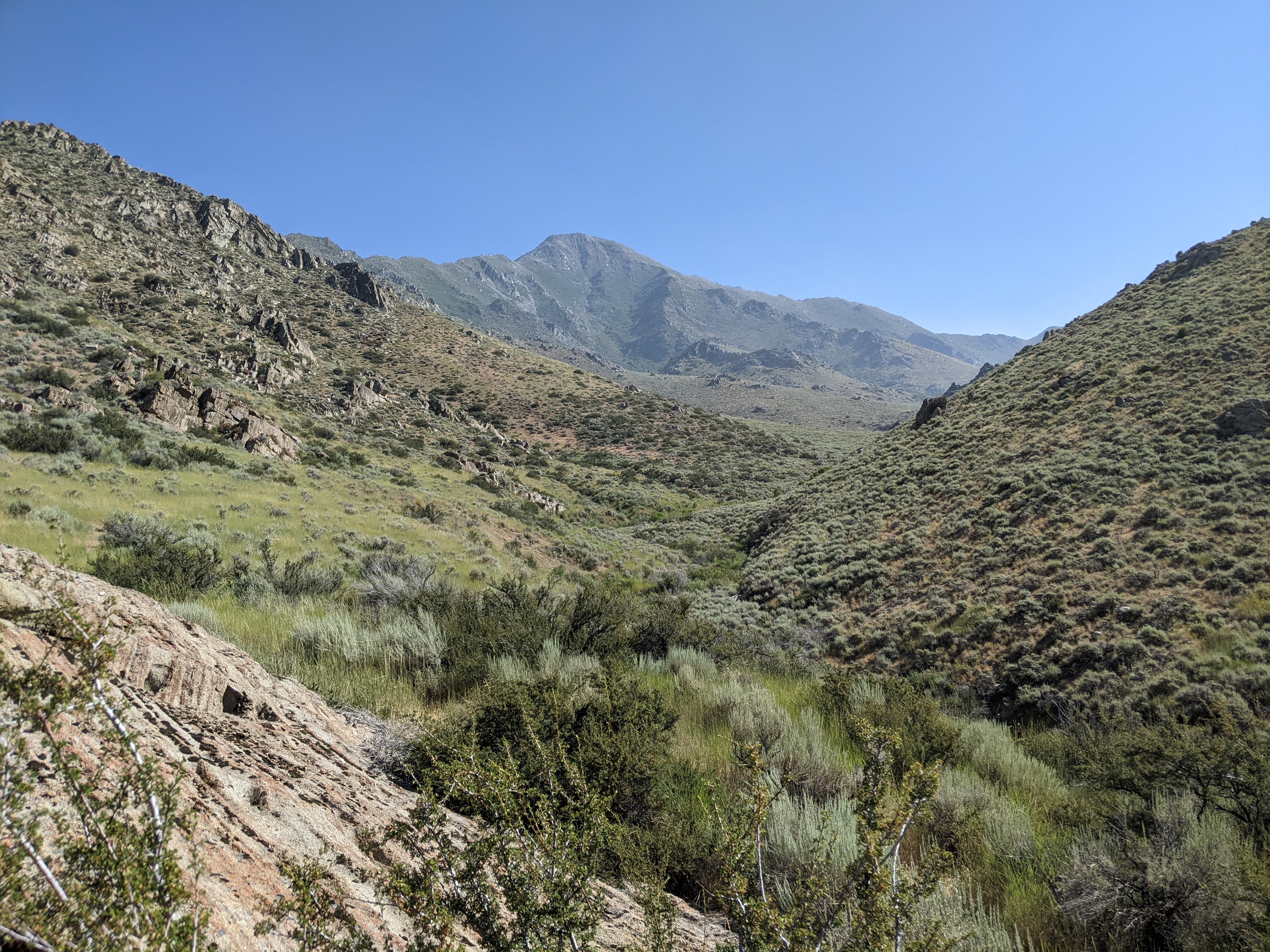
North of Winnemucca. Rugged, remote.

Not pictured - the super loud road to the right


Looking west over one of the houses at an old mining settlement on Spruce Mountain.


My son just got a job as a trail guide in Estes Park Co. anybody have any equipment suggestions for him? Stuff that most people forget about but is something that has become essential for you. Thanks in advance.


There are several trails around this lake which is a provincial park.

cross-posted from: https://lemmy.world/post/6218752 > Sorry for the wall of text, but as we put it all down, we realised that we had to add more and more criteria. > > We are planning our last trip for this year and are based in Germany. Our plans/funds unfortunately don't allow something as far away as Scotland/Sweden/... so we are looking in Germany, Denmark, BeNeLux, Western France, Austria or Switzerland. > > Ideally, this trail is not too much of a misery in autumn. We are fine with lots of ups and down, but not equipped for mountains or very alpine terrain in this time of the year. > We would be fine with huts or shelters, but could also wild camp (if it's no too much of a hassle). Doing just a certain section (5days max) would be fine for us as well. > > Bonus points for remoteness and beautiful nature. Walking along roads, forestry roads or villages all day is a bit monotone after a while. > > Might be that this does not exist; we enjoyed e.g. the West Highland Way very much and are looking forward for Sweden/Norway.

The water is usually crystal clear turquoise, but had just recently had monsoon storms there the week before we arrived. This was one of the most terrifying hikes I’ve ever done in my life and I doubt I will ever do it again. Absolutely stunning, though.
For me, it was to always bring a big water bottle (or two smaller ones). I just got back from a hike on one of the hottest days of the year where I ended up walking around 3 hours and several kilometers after running out of water during the hottest part of the day before I could get to a churchyard with an outdoor tap to fill up on. Not fun!


It rained last night, and they were everywhere.


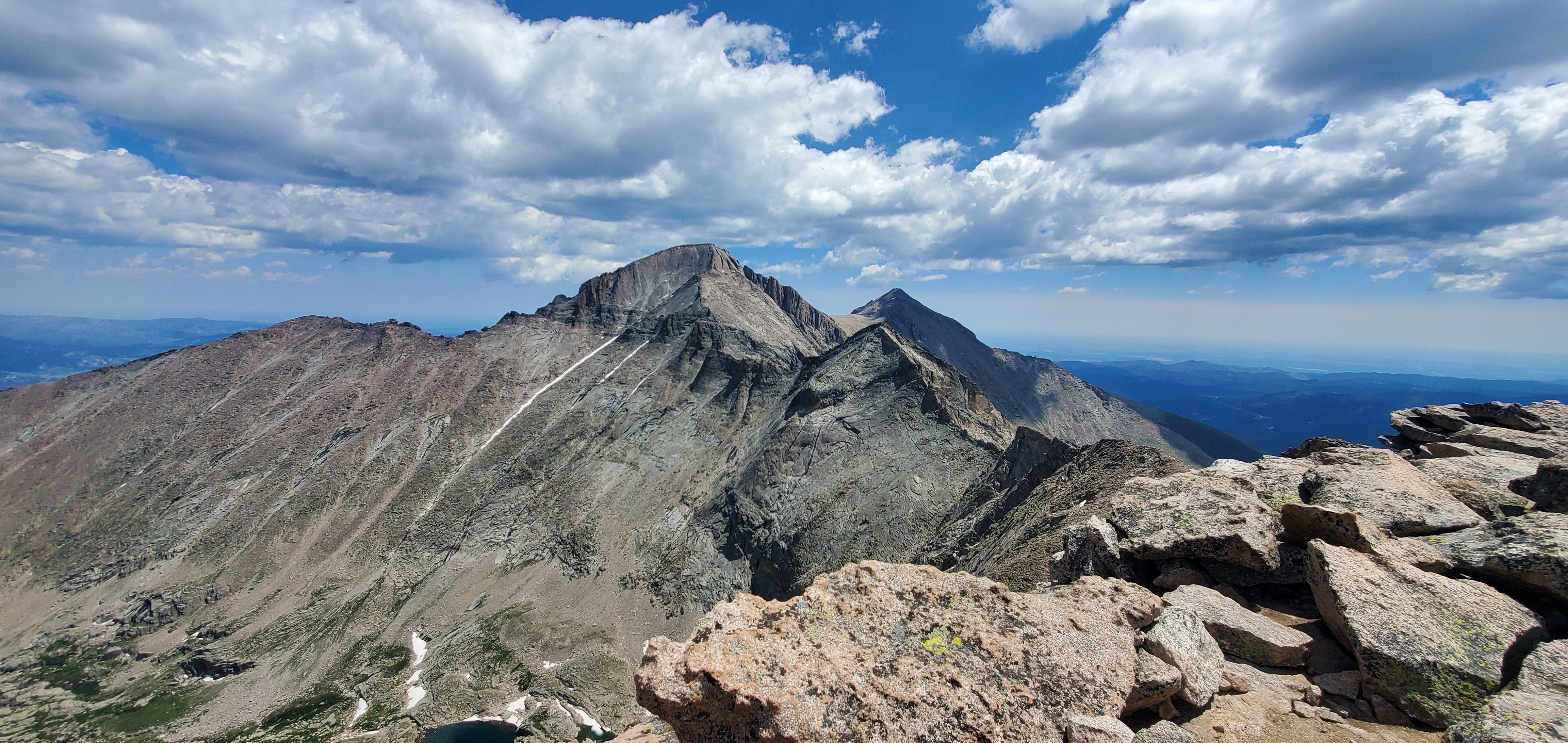
This photo was taken from the summit of [Chiefs Head Peak](https://www.summitpost.org/chiefs-head-peak/153014) looking east towards Longs Peak. In frame is [Storm Peak](https://www.summitpost.org/storm-peak/151406), [Longs Peak](https://www.summitpost.org/longs-peak/150310), [Keyboard of the winds](https://www.14ers.com/peaks/10190/keyboard-of-the-winds), [Pagoda](https://www.summitpost.org/pagoda-mountain/151710), and [Mt. Meeker](https://www.summitpost.org/mount-meeker/151182). From [Sandbeach TH](https://www.summitpost.org/sandbeach-trailhead/163808) in Wild Basin to the summit was 15.97 miles, 5.2K of elevation gain. Stats might be off a bit due to Garmin going Garmin, but it was a ass kicking hike and the payoff was so worth it.